AQUARIUS Funding Call – Marine and Freshwater Infrastructure Access: Open 02 September 2025 – 28 October 2025


Infrastructure Profile
Infrastructure Provider
Location/Home Port
Piraeus, Greece
Organisation & Address
Hellenic Centre For Marine Research, 46,7 km Athinon-Souniou Avenue, 19013 Anavyssos, Attica, Greece
Normal Area of Operation
Aegean Sea, Ionian Sea, South Cretan Sea, Mediterranean Sea, Black Sea, Red Sea to 17 degrees north
Maximum Number of Days Available
15 days
Scientists’ Travel and Logistics (T&L) Budget Available
€ 15,000.00
Overview
Length
61.51 m
Breadth
9.6 m
Draught
2.9 m
Gross Tonnage
778 T
Ice Class Rating
NA
Dynamic Positioning (DP) Rating
NA
Service Speed
12 knots
Maximum Number of Scientific Berths Available
20 berths available
Scientific and Technical Specifications
Laboratory Facilities
Wet, chemistry and water labs, Dry Lab, freezers (-20,) and refrigerators
Capacity to carry 1x 20 ft containerized labs
Meteorological station
CTD/Plankton sampling
CTD and Rosette sampler – 2 x SBE 911plus CTD with SBE 32 carousel (24 x 10 lt or 12 x 12 lt Niskin Bottles), 6000 m deployment capability. CTD equipped with temperature, salinity, pressure, dis. Oxygen, turbidity, fluorescence sensors.
Towed and lowered plankton nets (Including Multi-net)
Multi-Beam(s)/Sub Bottom profiling
Multibeam sonar (Wärtsilä ELAC SeaBeam 3030)
Side Scan Sonar,
Pinger Sub Bottom Profiler,
Airgun Seismic profiler (single channel seismic),
New multichannel seismics,
Various samplers for benthos and sediment coring,
GPS Satellite heading
Fisheries Echo Sounders/Sonar
NA
USBL
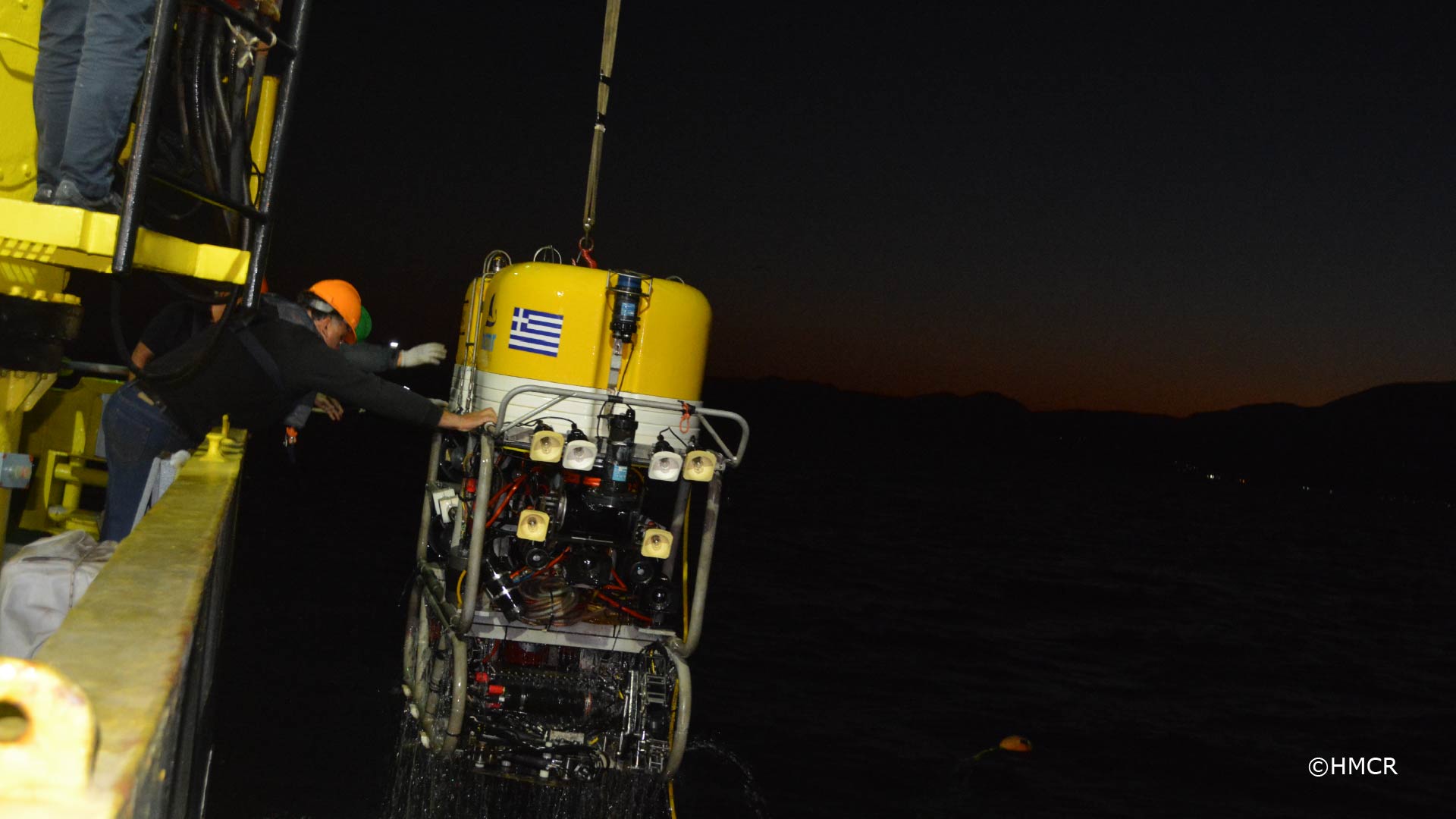
ROV use only
Coring/Sampling Capabilities
Gravity corer 70 mm diameter, up to 5 m length
Box corer 40x40x60 cm (length-width-depth)
Multicorer with 8 PMMA core tubes
Possibility to host vibrocorer
Winches
Stern hydraulic A-frame SWL 10 ton, 7.3 m height
1 main crane 3.5 ton
2 winches, 3500 m centrally remotely controlled, 10 ton
Oceanographic winch x 6000 m
Oceanographic winch x 2000 m
Communications
2 x VHF FURUNO FM-8800S.
3 x PORTABLE VHF transceiver(GMDSS) THRANE + THRANE MC MURDO R5 2W
Navigation messages receiver Navtex MC MURDO NAV-7
AIS TRANSPONDER EM-TRAK MARINE ELECTR.LTD A200
VHF TRANCEIVER (AIRBAND) ICOM IC-A16E 6.0/1.8W
MHF GMDSS SYSTEM NEW SUNRISE(NSR) NHR-1500
AIS-SART OROLIA LTD KANNAD MARINE SAFELINK AIS-SART2
SART 9 GHZ JOTRON AS TRON SART 20
AIS-EPIRB 406 MHZ(MANUAL) JOTRON AS TRON 60 AIS
EPIRB 406 MHZ(AUTOMATIC) JOTRON AS TRON 60s
2 x INMARSAT-C MES+EGC RECVR FURUNO FELCOM-18 12/16 DBW
Special features
Ship is equipped with 75 kHz RDI Ocean Surveyor hull-mounted Acoustic Doppler Current Profiler (ADCP). Possibilities to set up small-scale scientific equipment, can be used as a platform to use and deploy drones, gliders, buoys. Handling of AUVs or non HCMR ROVs will be considered case-by-case.
Suitable Surveys
Multipurpose research vessel. Suitable for carrying out a wide variety of scientific survey operations in offshore and deep-sea locations. The vessel is adapted to accommodate a variety of Remotely Operated Vehicles.
Vessel capable of Hydrographic survey, Oceanographic surveys, Mooring deployments, Seismic surveys, ROV Surveys, Benthic surveys.
Scientific Limitations
No fisheries
Vessel capability to support ROV deployment
Yes, capable, has deck space with 380 V power supply
Positioning is carried out manually by deck officers and USBL
Crane and A-Frame for Launch and recovery
Positioning is carried out manually by deck officers and USBL
Crane and A-Frame for Launch and recovery
Support offered to AQUARIUS users
All vessel equipment will be made available to AQUARIUS Users on request. Technical support on vessel equipment will be available during the entire survey.
Infrastructure Availability and Contact Details
Year 2025
R/V AEGAEO will operate into the Eastern Mediterranean Sea between the North latitudes: 41° 00,00΄ to 33° 30,00΄ and East longitudes: 019° 00,00 ΄ to 034° 00,00΄
There is also one expedition on 2025 into the EEZ of Saudi Arabia into the Red Sea between the North latitudes: 27° 55,00΄ to 17° 00,00΄. Available for 2-3 weeks from April to October. We need at least 6 months’ notice. Port of Operation: Piraeus GR.
Year 2026
R/V AEGAEO will operate into the Eastern Mediterranean Sea between the North latitudes: 41° 00,00΄ to 33° 30,00΄ and East longitudes: 019° 00,00 ΄ to 034° 00,00΄
There is also one expedition on 2025 into the EEZ of Saudi Arabia into the Red Sea between the North latitudes: 27° 55,00΄ to 17° 00,00΄. Available for 2-3 weeks from April to October. We need at least 6 months’ notice. Port of Operation: Piraeus GR.
Year 2027
R/V AEGAEO will operate into the Eastern Mediterranean Sea between the North latitudes: 41° 00,00΄ to 33° 30,00΄ and East longitudes: 019° 00,00 ΄ to 034° 00,00΄
There is also one expedition on 2025 into the EEZ of Saudi Arabia into the Red Sea between the North latitudes: 27° 55,00΄ to 17° 00,00΄. Available for 2-3 weeks from April to October. We need at least 6 months’ notice. Port of Operation: Piraeus GR.
Contact email for applicants to discuss the initial feasibility of their work while they prepare their application
n.lamprianos[at]hcmr.gr
Certification and Clearance Requirements
Medical Certification Requirements
No certification required by scientists and or technicians other than seamen
Are additional medical checks required?
No medical check required for personnel other than seamen
Survival training certification required for joining vessel
None required. The participants are obliged to attend training on board.
Additional certification required
Every member of the research team must participate in the safety and laboratory training before every cruise
Diplomatic clearance or other permits required and any relevant information about the application process
Under the United Nations Convention on Laws of the Sea (UNCLOS) MSR/Diplomatic clearance is required for research cruises taking place in other EEZs (national jurisdictions other than the vessel’s own). Application forms should be submitted via Diplomatic Channels (Government Foreign Departments/Ministries) 6-7 months prior to sailing by Principle Investigators in conjunction with the vessel operator. RV Vessel Operations department will generally administer the application process but please consult with the operators in advance.
Any additional clearances required for area or type of activity
Every cruise needs to be approved by the Commission for Granting Permits for Marine Research Cruises, which operates within the Ministry of Foreign Affairs. The Maritime Department of HCMR will undertake any necessary action to obtain the permits. Permit requests need to be submitted to the Commission at least 3 months before the cruise.
• Seismic operations require additional permits
Other requirements for other jurisdictions to be addressed via Diplomatic clearance process.
Additional training required
Safety training and introduction to the platform facilities during first visit are required. The Infrastructure Operator will provide the training.